PUTING BATO x CANIBAD
We were in the middle of a one-man trail in a pitch-black forest at around 12 midnight when I felt Drowsy. There were only eight of us trudging the dark surroundings and our headlamps are the only source of light we had.
This hike was impromptu but I, together with my partner, decided to tag along anyway. Our team left our village bound to Sasa Wharf at around 10 in the evening and we came unprepared. We managed to buy some raw meats at the public market of Sasa to serve as our dinner at the camp before we embarked to the ferry going to the Island of Samal. Another 20 minutes and we arrived at Samal Island. The voyage was as calm as the sea. The fare only costs 15Php per head. Upon arriving at the port, we were stormed by Habal-habal riders, wanting to win us as their last passenger of the day. There are two jump-off locations that will take you to Puting Bato Peak. Guilon and Tayapok Trail. Tayapok trail is the easiest way to the peak while Guilon is open for those who want a quite challenging trail. We were taking the Guilon trail, of course. Habal-habal fare going to Guilon Jump-off point was at 250Php per head but then we managed to bargain it down to 150Php per head.
It was already 12 midnight when we arrived at the jump off point. Nobody else was there but only the eight of us and two drivers who drove off after they dropped us. The mood was so quiet and eerie. The only source of light illuminating the surrounding comes from the moonlight. We gathered our strengths as we offered a short prayer for the safety of our ascend and then we moved on. We took the one-man trail digging into the black forest. We had our headlamps and cell phone flashlights turned on to guide us on every step towards the slight ascend. 30 minutes into the trail, we found ourselves traversing the steep limestone on a cliff edged trail while catching our breath. That was the time I felt uncomfortable and decided to take some rest. My back hurts more than ever. Later did I realize that my chaotic packing of things was the reason for me being weary. We laze down for a while to regain energy and continue ascending to the campsite to finally rest. I didn’t bother arranging my things as we are already half of the climb.
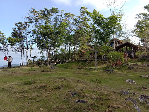
After more than an hour of assault, we were able to reach the first campsite. Puting bato has 3 campsites that offer different views. You can actually camp on the 3 campsites and it just depends on what camp setting you prefer because each of them offer different vibes. Your first campsite varies on what trail you are traversing too. Second campsite or also known as “Huyong-huyong” is the 2nd highest campsite of Puting Bato. It is also the best place to camp as the area has a wide almost-flat land for tent pitching and quite a lot of trees if you prefer hammock. Third Campsite (or the 1st campsite if you are trailing Tayapok) is the highest point of Puting Bato. We paid 20Php for the entry fee at the 1st campsite, logged our names on the book and continued hiking for another 20 minutes before we arrived at the 2nd campsite where we will be staying for the rest of the night. We again paid 20Php for the entry fee plus another 20Php for the overnight stay with free water supply. We settled our tents and had our midnight dinner before we took some booze and cap the night.
Traversing CANIBAD
Hikers prefer to relax at a cold waterfall or at the beach after a long and tiring hike and among the famous traverse options you can do when in Puting Bato is going to Canibad.
We had our breakfast at the campsite around 8AM before we camped out. After taking some Photographs at Puting Bato’s highest point, we continued our long journey. We needed to start descending to Tayapok so we could reach Canibad just before lunch. Canibad is 7kms away from Puting Bato Peak if you are trailing the circumferential road. That is not our case. We are walking along a one-man trail from Tayapok all the way to Canibad. The exciting part is, we have no guide to lead us to the right path. All we have was our google maps that somehow gave us the direction using the trail guide on the actual map itself. It took us about 4 hours to descend before we arrived at Canibad’s main road.
The trail, although, downhill, has its own share of challenges. There are times when we almost got lost at the vast cornfield because of the confusing junction, got dehydrated in an open field under the direct heat of the sun with our empty Nalgenes, slid on the steep downhill because of the dead leaves along the trail. It was all fun yet tiring traverse and thankfully we arrived at our destination safe and sound.
Almost 1PM when we settled in one of the beaches of Canibad. There we cooked our late lunch and enjoyed the rest of the day at the beach. It was a very tiring traverse but it was super fun.
Here's my video compilation of our Puting Bato Hike:
Here's my video compilation of our Puting Bato Hike:
.png)


0 comments: